Bild:ArmeniaNumbered.png
Wikipedia

| | Denna fil tillhandahålls av Wikimedia Commons. Informationen från filens beskrivningssida följer nedan. |
  It is recommended that the other file be used. If you just added this tag and want to nominate this image for deletion, please add the following code to here: (Please review the discussion here.)
Afrikaans | Alemannisch | العربية | Česky | Dansk | Deutsch | English | Ελληνικά | Esperanto | Español | Français | Galego | עברית | हिन्दी | Magyar | Bahasa Indonesia | Ido | Italiano | 日本語 | 한국어 | Nederlands | Norsk (nynorsk) | Polski | Português | Românǎ | Русский | Slovenščina | Српски | Svenska | Türkçe | 简体中文 | 正體中文 | +/- |
[edit] Summary
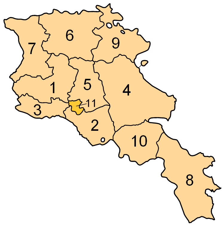
Subdivisions of Armenia. Map created by w:en:user:Golbez. Coloured by w:en:user:Clevelander.
[edit] Licensing
 |
Permission is granted to copy, distribute and/or modify this document under the terms of the GNU Free Documentation License, Version 1.2 or any later version published by the Free Software Foundation; with no Invariant Sections, no Front-Cover Texts, and no Back-Cover Texts. A copy of the license is included in the section entitled "GNU Free Documentation License".
العربية | Česky | Deutsch | English | Español | Français | Italiano | 日本語 | 한국어 | Nederlands | Polski | Português | Slovenčina | Svenska | עברית +/- |
Image shows the eleven administrative subdivisions of Armenia:
- Aragatsotn (Արագածոտնի)
- Ararat (Արարատի)
- Armavir (Արմավիրի)
- Gegharkunik (Գեղարքունիքի)
- Kotayk (Կոտայքի)
- Lori (Լոռու)
- Shirak (Շիրակի)
- Syunik (Սյունիքի)
- Tavush (Տավուշի)
- Vayots Dzor (Վայոց Ձորի)
- Yerevan (Երևան) - special administrative status
Bildlänk
Följande sidor länkar till denna bild:

