
U.S. Route 101
From Wikipedia, the free encyclopedia
 |
|||||
| U.S. Route 101 |
|||||
 |
|||||
| Length: | 1540 mi[1] (2478 km) | ||||
|---|---|---|---|---|---|
| Formed: | 1926[1] | ||||
| South end: | |||||
| Major junctions: |
|||||
| North end: | |||||
|
|||||
-
Highway 101 redirects here. For the country-western band, see Highway 101 (band). For other highways numbered 101, see Route 101.
U.S. Route 101, or U.S. Highway 101 (often just US 101), is a north-south highway that runs parallel to the West Coast of the United States. It should not be confused with California's own State Route 1, also known as the Pacific Coast Highway. U.S. Route 101 is often referred to as the Oregon Coast Highway in Oregon, and as the Pacific Highway in parts of Washington and California. Colloquially, the highway is also referred to as The 101 by residents of Southern California or simply 101 by residents of Northern California and Oregon. Through much of California, the road is also known as El Camino Real (The Royal Road), as its route along the southern and central California coast approximates the old trail which linked the Spanish missions, pueblos and presidios.
U.S. Route 101 was once the major north-south link along the Pacific coast. It has been replaced in importance by the highways of the Interstate Highway System, specifically Interstate 5, which is more modern in its physical design. Route 101 is still in use as an alternative to the Interstate for most of its length. A notable exception is where the alignment is shared with that of I-5 and the route number U.S. Route 101 has been changed to I-5, beginning about one mile (1.6 km) east of downtown Los Angeles and continuing south to San Diego.
In northern California, it passes through, and was important in the creation of, the Redwood National and State Parks.[citation needed] In the San Francisco Bay Area, it (along with Interstate 280) is one of the major commuter routes carrying residents of Marin, Sonoma and San Mateo Counties into downtown San Francisco, as well as San Jose and other cities that make up Silicon Valley. The route crosses the San Francisco Bay, from the city of San Francisco to Marin County, over the Golden Gate Bridge.
In Southern California, the highway is a heavily traveled commuter route serving the west side of the greater Los Angeles area. The route follows the Hollywood Freeway west from Downtown Los Angeles through the Cahuenga Pass before turning west onto the Ventura Freeway. Communities along the alignment include Hollywood and the southern edge of the San Fernando Valley, and the cities of Burbank, Thousand Oaks, Camarillo, Oxnard, Calabasas,and Agoura Hills.
Contents |
[edit] Major cities
- Los Angeles, California
- Oxnard, California
- Ventura, California
- Santa Barbara, California
- Santa Maria, California
- San Luis Obispo, California
- Salinas, California
- San Jose, California
- San Francisco, California
- Santa Rosa, California
- Olympia, Washington
[edit] Route summary

[edit] California
[edit] Greater Los Angeles
The south terminus of U.S. Route 101 is in Los Angeles, about one mile east of downtown Los Angeles at the East Los Angeles Interchange. This southernmost portion is named the Santa Ana Freeway, inheriting that title as the northerly extension of the roadway now known as Interstate 5. After merging with westbound traffic from the San Bernardino Freeway (I-10), U.S. Route 101 then proceeds northwest via the Downtown Slot under the northern edge of Los Angeles' Civic Center to State Route 110 at the Four Level Interchange.
Between Route 110 and the junction with the State Route 134 (CA/SR-134) and State Route 170 (CA/SR-170), US 101 is known as the Hollywood Freeway. At the junction with CA/SR-134 and CA/SR-170 (known as the Hollywood Split) the alignment of US 101 "shifts" to the alignment of CA/SR-134 (i.e. heading northbound, the road's alignment turns left, or westbound) and thereafter is referred to as the Ventura Freeway. Confusingly, the "Hollywood Freeway" name continues northward from this interchange on CA/SR-170, and the "Ventura Freeway" name continues eastward to CA/SR-134.
From the Hollywood Split, US 101 is an east-west highway until it reaches Gaviota State Park where it shifts back to a north-south alignment. The east-west geographical alignment of the Ventura Freeway and the north-south designation on freeway signs can be confusing to visitors. The same freeway entrance can often be signed as "101 North" and "101 West"; this is most common in the San Fernando Valley. From Ventura to Gaviota State Park, which is about 23 miles (37 km) west of Goleta, US 101 closely follows the Pacific coastline (generally no more than one to two miles from the shore).
North of Ventura the highway alternates between freeway and expressway segments; on the expressway segments, there are at-grade intersections (see the articles on freeways and expressways for more information on the California definition of "expressway"). However, there are no traffic lights on the mainline until one arrives at San Francisco. The last traffic signals on the highway south of San Franciso were removed in the early 1990s when the section through downtown Santa Barbara was constructed (after years of resistance from the Santa Barbara community). Cities along the alignment north of Ventura include Santa Barbara, Santa Maria, San Luis Obispo, Salinas, and Gilroy.

[edit] Central Coast
The highway passes through the Gaviota Tunnel 1 mile north of the point where the road curves away from the ocean and heads due north. A few miles north of the Gaviota Tunnel, California State Route 1 splits from US 101. Farther north, California State Route 1 rejoins the 101 for a section between Pismo Beach and San Luis Obispo. Then US 101 takes an inland route through the Salinas Valley, while Highway 1 heads northwest, running along the Pacific coastline in California, parallel and to the west of US 101.
The extremely steep segment (8% grade) between San Luis Obispo and Atascadero is known as the Cuesta Grade. North of Atascadero, the highway joins State Route 46 (CA/SR-46) for about three miles through Paso Robles
From Paso Robles to Salinas, US 101 is an expressway known as the Salinas River Valley Highway, since the Salinas River Valley extends from Santa Margarita to the State Route 156 (CA/SR-156) Junction in Prunedale.

[edit] San Francisco Bay Area
From Gilroy to San Jose, US 101. becomes a freeway called the South Valley Freeway. From San Jose to San Francisco, Route 101 is the Bayshore Freeway. This segment was originally Bayshore Boulevard, later redesignated the 101A bypass and upgraded to freeway by the late 1950s. This section of 101 from San Jose north to San Francisco is very heavily-travelled; some motorists call 101 "the world's longest parking lot".[citation needed] From the San Francisco city/county line until the junction with Interstate 80 it is named the James Lick Freeway. After that Route 101 is briefly named the Central Freeway before the divided highway ends and traffic follows city streets. US 101 then runs north on Van Ness Avenue and before turning left at Lombard Street (turning right on Lombard leads one to the Crookedest Street in the World). From Lombard Street, northbound US 101 traffic is shifted to Richardson Avenue, then Doyle Drive entering The Presidio, where it becomes a divided highway again, joining Route 1 to cross the Golden Gate Bridge into Marin County.

North of the Golden Gate Bridge, US 101 is known as the Redwood Highway. From there to the Oregon border, the highway is in some places a freeway and in others a two-lane road. After crossing the bridge, US 101 passes through the Waldo Tunnel, the first of its kind in 300 miles (the other being the Gaviota Tunnel in Santa Barbara County), before passing through the major cities of Marin County. It then reaches Sonoma County, where it becomes a heavily-traveled, four lane freeway, which will be upgraded to six lanes by 2010. The highway continues through California's Wine Country, and past a sometimes narrow river valley with the Russian River before leaving Sonoma County and entering Mendocino County.
[edit] North Coast
US 101 then passes through Humboldt County, where it travels through Humboldt Redwoods State Park and a portion of the highway that is known as the Avenue of the Giants for the huge, centuries-old redwood trees that can be found there. After reaching Eureka, the highway closely follows the Pacific coast again. The building of the highway led to increased awareness of the destruction of the redwoods, which led to the establishment of the Redwood National and State Parks, which the highway passes through.[1] Shortly north of Crescent City, US 101 intersects with U.S. Route 199, which heads northeast as the Redwood Highway, terminating in Grants Pass, Oregon. US 101 (no longer called the "Redwood Highway" at this point) continues north along the California coast until it reaches the Oregon border.

[edit] Oregon
U.S. Route 101 enters Oregon four miles south of Brookings, and is seldom out of sight of the Pacific Ocean until it reaches Astoria; the major exception being a significant inland stretch south of Tillamook, Oregon. It crosses the Siuslaw River Bridge in Florence. The stretch between Florence and Yachats is considered one of the more attractive segments of this highway. There are a number of Oregon state parks along the Pacific coast, including the Heceta Head Lighthouse. Because US 101 forms the main street of almost all of the coastal towns in Oregon (with the exception of Cannon Beach and others), it is frequently, but not always, congested and slow. The highway crosses the mouth of the Columbia River over the 4-mile-long Astoria-Megler Bridge at Astoria into Washington, and follows the Columbia downstream to Ilwaco.

[edit] Washington
From Ilwaco, US 101 follows the Pacific coastline as far as Raymond, from which it proceeds directly north to Aberdeen, offering access from this city into the Olympic National Park. While the AAA has designated this segment north and then east to Port Angeles and Sequim as a scenic byway, some clear-cut logging in the early 1990s has diminished the scenic value of the highway where it crosses the Quinault Indian Reservation. An expressway goes through Sequim. East of Port Angeles, Route 101 turns southward, leading to Shelton and its northern terminus in Olympia, the state capital. Upon reaching Shelton, US 101 turns into a two lane bypass that changes to a freeway at the junction of State Route 3, merging with State Route 8 and finally ending at Interstate 5.
[edit] Historic routes
- Parts of Historic Route 101 can still be found in San Diego County between Oceanside and the border with Mexico under a variety of different names. Through Oceanside it's Coast Highway. In Carlsbad it becomes Carlsbad Blvd, but to the south in Encinitas it's Coast Highway 101. Solana Beach keeps it consistent with Highway 101, but Del Mar changes it to Camino Del Mar. All of those together make up San Diego County Route S21. From there it continues along Torrey Pines Road to Interstate 5 in La Jolla. The old 101 routing continues on I-5 in San Diego until Pacific Highway, the old US 101 freeway a little west of current I-5. It then continued on Harbor Drive and Broadway through Downtown San Diego and Chula Vista, then onto National City Blvd in National City. The southern parts of I-5 were US 101 for a period before I-5 was completed also. All have been decommissioned, but the roadways still exist and are occasionally signed as Historic 101.
- Most of Historic 101 between Gilroy and San Francisco is still active, either signed as Business 101 or as State Route 82. The 101A bypass, however, is mostly discontinuous and is paralleled by the actual freeway, in some cases serving as an access road to the freeway.
- Large parts of the old U.S. Business 101 and State Route 82 surface roads between San Francisco and San Diego are designated El Camino Real (The Royal Road), a designation originally given any thoroughfare under the direct authority of the King of Spain and his viceroys. These portions constitute the first major road in California.
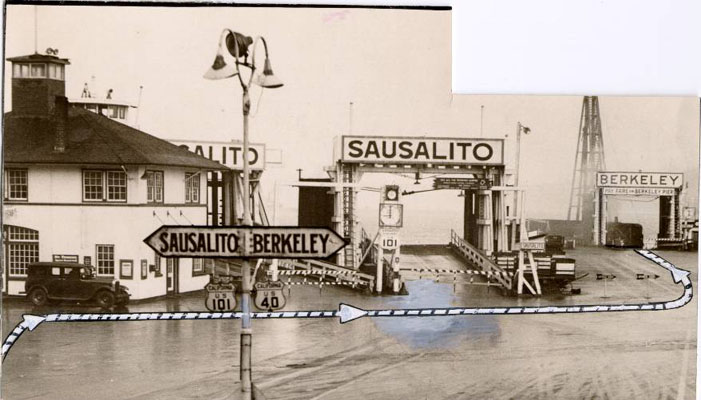
- Before the Golden Gate Bridge was completed, Highway 101 was divided in the San Francisco Bay Area. 101-W (west) followed the same general right-of-way of today's 101 from San Jose to San Francisco. 101-E (east) generally followed the right-of-way taken by today's I-880 from San Jose to Oakland. Since there was no Golden Gate Bridge yet, 101-W became a ferry ride across the Golden Gate Strait. As today, 101-W proceeded up Van Ness, but without any left turn at Lombard, ending at the Hyde Street Pier. From there, motorists would drive onto a ferry boat which would cross the Golden Gate to Sausalito, where they would drive off the ferry directly onto the main street of Sausalito, which was signed for US 101 once again.[2]
 Road sign on the 101 at Encinitas |
 Former US 101 in North San Diego County |
 Historic Route 101 in Solana Beach, San Diego County California |
[edit] Termini
As of 2006, the highway's "northern" terminus is in Olympia, Washington; though the northernmost point on the highway is roughly around Port Angeles. The highway runs north through Washington, running parallel to the Pacific Coast, all the way up the western side of the Olympic Peninsula. In the northwestern part of the peninsula, the highway turns east, and runs along the peninsula's northern edge, parallel to the Strait of Juan de Fuca. In the peninsula's northeast corner, the highway then turns south, running along the eastern edge of the peninsula and along the western shore of Hood Canal, until the highway terminates at a junction with Interstate 5 in Olympia. Between the intersection with State Route 112, on the western edge of the Olympic Mountains, US 101 is signed east/west, and roughly south of the intersection with State Route 20, US 101 is signed north/ south but having turned around 180 degrees. The direct route between the towns of Aberdeen (on the coast) and Olympia is US 12 and State Route 8.
The southern terminus of US 101 is in Los Angeles, California at the East Los Angeles Interchange, the world's busiest freeway interchange.[3]
[edit] States traversed
The highway passes through the following states (north to south):
[edit] Related U.S. routes
- U.S. Route 1 (not actually the "parent" of US 101)
- U.S. Route 99
- U.S. Route 101 Alternate (since 1964 replaced with California State Route 1)
- U.S. Route 101 Bypass (all segments eliminated by 1965)
[edit] Trivia
- Mentioned in the Phantom Planet song "California", the Jackson Browne song "Running on Empty", the Social Distortion song "Highway 101", the Tori Amos song "A Sorta Fairytale", the Hayley and the Vibe song "101", The Ataris song "1*15*96," the Fountains of Wayne song "Bought for a Song," and Tom Petty's song "Free Fallin'."
- Lewis Black also mentions the freeway on his "Luther Burbank Performing Arts Center Blues," which was recorded in Santa Rosa, California.
- In the video game Sonic Adventure 2, there are two racing levels: "Route 101" (named after U.S. Route 101) and "Route 280" (named after Interstate 280). Both highways run through San Francisco, California. San Francisco is also the home of the North American headquarters of Sega, the company that produces the Sonic the Hedgehog series of video games.
- A scene in Crocodile Dundee in Los Angeles, Mick skids to a stop in the middle of the freeway causing a major pile-up. Later in the movie, news reports covering the incident describe it as "Route 101".
- The highway is also featured in Cruis'n USA, a racing game in which players drive across the country.
- In addition to this, the Golden Gate Bridge, which carries 101, has been featured in many pop culture references.
- In Washington State, between State Route 112 and State Route 20, U.S. 101 is signed east-west, similar to Interstate 69 between Lansing and Port Huron, Michigan. From Highway 20 to Interstate 5, U.S. 101 is signed north-south again. However, when considering the overall direction of the highway, the north and south markers are reversed.
- Unlike Washington State, California does not sign the long east-west section of U.S 101 between Point Conception and the intersection of California State Routes 134 and 170 in North Hollywood as "west" and "east." Instead, CalTrans observes the overall direction of the highway and marks it "North 101" and "South 101." However, radio traffic reporters in the area refer to the directions on this section of U.S. 101 (especially the section of the Ventura Freeway from Oxnard to North Hollywood) as "Westbound 101" and "Eastbound 101." Along this section, westbound is marked "north" and eastbound is marked "south."
[edit] See also
[edit] References
- ^ a b US Highways from US 1 to US 830 Robert V. Droz
- ^ http://webbie1.sfpl.org/multimedia/sfphotos/AAC-2256.jpg
- ^ http://www.scvresources.com/highways/east_los_angeles_interchange.htm
[edit] External links
- Historic California US Highways
- East Los Angeles Interchange Complex
- Endpoints of US highways
- Western Exit Guide - US 101 California
| Main U.S. Routes | |||||||||||||||||||
| 1 | 2 | 3 | 4 | 5 | 6 | 7 | 8 | 9 | 10 | 11 | 12 | 13 | 14 | 15 | 16 | 17 | 18 | 19 | |
| 20 | 21 | 22 | 23 | 24 | 25 | 26 | 27 | 28 | 29 | 30 | 31 | 32 | 33 | 34 | 35 | 36 | 37 | 38 | |
| 40 | 41 | 42 | 43 | 44 | 45 | 46 | 48 | 49 | 50 | 51 | 52 | 53 | 54 | 55 | 56 | 57 | 58 | 59 | |
| 60 | 61 | 62 | 63 | 64 | 65 | 66 | 67 | 68 | 69 | 70 | 71 | 72 | 73 | 74 | 75 | 76 | 77 | 78 | 79 |
| 80 | 81 | 82 | 83 | 84 | 85 | 87 | 89 | 90 | 91 | 92 | 93 | 94 | 95 | 96 | 97 | 98 | 99 | ||
| 101 | 163 | 400 | 412 | 425 | |||||||||||||||
| Lists | U.S. Routes - Bannered - Divided - Replaced | ||||||||||||||||||
| Browse numbered routes | ||||
|---|---|---|---|---|
| < |
CA | SR 102 |
||
| < |
WA | I-182 |
||
|
|
State routes in Washington related to US 101 |
| SR 100 (Spur) - SR 102 - SR 103 - SR 104 - SR 105 (Spur) - SR 106 - SR 107 - SR 108 - SR 109 (Spur) - SR 110 (Spur) - SR 112 - SR 113 - SR 114 - SR 115 - SR 116 - SR 117 - SR 119 | |
| Former or proposed State Routes: SR 111 - SR 118 | |

