
படிமம்:IVC Map.png
கட்டற்ற கலைக்களஞ்சியமான விக்கிபீடியாவில் இருந்து.

IVC_Map.png (110KB, MIME type: image/png)
 |
Permission is granted to copy, distribute and/or modify this document under the terms of the GNU Free Documentation License, Version 1.2 or any later version published by the Free Software Foundation; with no Invariant Sections, no Front-Cover Texts, and no Back-Cover Texts. A copy of the license is included in the section entitled "GNU Free Documentation License".
العربية | Česky | Deutsch | English | Español | Français | Italiano | 日本語 | 한국어 | Nederlands | Polski | Português | Slovenčina | Svenska | עברית +/- |
see also en:Image:Indus_Map.jpg, Image:CiviltàValleIndoMappa.png, de:Bild:Karte Harappa.png
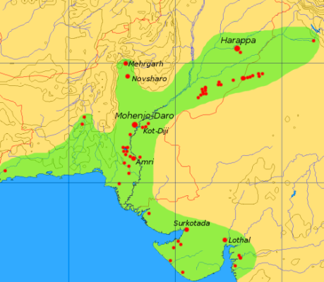
This map is a provisional outline of the Indus Civilization based on online sources. It is the best GFDL map we have so far, but it should be redrawn with greater accuracy and proper source attribution.
The main source of the present map is a scan of some unidentified publication, [1].
Better maps:
படிம இணைப்புகள்
பின்வரும் பக்கங்கள் இப் படிமத்துக்கு இணைக்கப்பட்டுள்ளன:


![[1]](http://content.answers.com/main/content/wp/en/thumb/d/dd/350px-Indus_Map.jpg)
![[2]](http://www.sp.uconn.edu/~gwang/indusVic.png)